Spacesium and Esri advance mining technology capabilities
June 16, 2025

🗺️Spacesium & Esri: Bringing Next-Gen Geospatial Power to Mines in Australia
We’re thrilled to announce a landmark collaboration between Spacesium and Esri, aimed at transforming how mines in Australia operate, plan, and adopt mining technology. By combining Spacesium’s deep domain expertise in mining technology with Esri’s cutting-edge geospatial tools, we’re unlocking new capabilities for safety, efficiency, and sustainability.
Why This Matters
Mining is increasingly data-driven. To get ahead of challenges—from safety incidents to environmental compliance to operational efficiency—mine operators need fast, accurate location-based insights. That’s where geospatial intelligence comes in.
Through its strategic alliances, Esri has established strong solutions for organizations needing to bring together operational data and location intelligence. Spacesium Technology : Esri’s ArcGIS technology supports Spacesium technology stack, giving users a fully managed GeoAI Toolboxes with spatial engine capabilities. The result is real-time access to all kinds of analytical data—SAP data, non-SAP data, spatial data—all in one place with strong analytics, scale, and lower maintenance overhead.
This partnership enables mining companies globally to tap into:
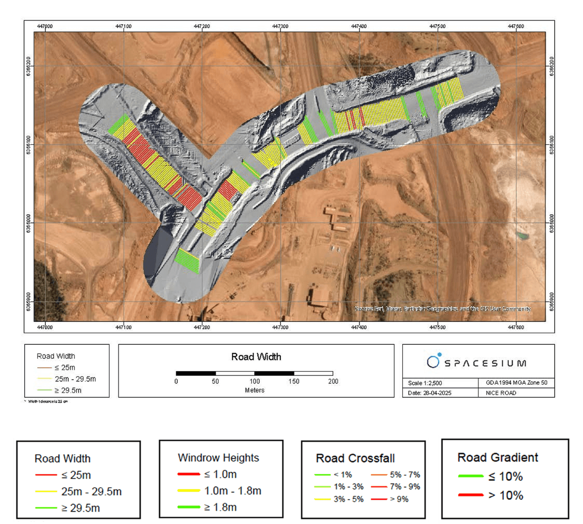
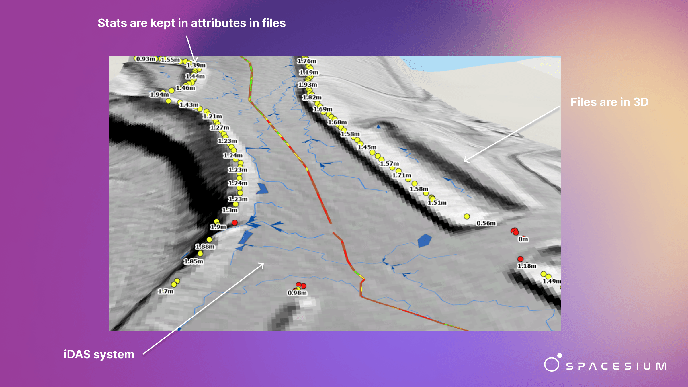
Rapid, Accurate Spatial Workflows: Automatically process large volumes of LiDAR, drone/satellite imagery, photogrammetry. Generate terrain models, detect changes, monitor assets, all with greater speed and less manual effort.
Safety & Compliance Enhancement: Tools like Scout Sentry help ensure road and site safety compliance; automated monitoring can flag areas of concern before incidents occur.
Change Detection & Reporting: Scout Shift enables mines to detect what’s changed over time—surface alterations, erosion, structural shifts—enabling more responsive operations and environmental monitoring.
Volumetric Analytics: Using StockScanIQ and related toolsets to measure stockpiles, volumes, cut/fill with precision—critical for planning, extraction, processing, and financial forecasting.
Scalability & Integration: Solutions that plug into existing ArcGIS environments; support both cloud and on-premises; able to support frequent, high-volume spatial data ingestion and processing.

Benefits & Use Cases
Here are a few ways mining operations can immediately benefit:
Monitoring haul road conditions or slope stability via periodic scans and imagery, triggering maintenance or preventative work.
Environmental impact assessment: tracking land use change, vegetation loss/regrowth, tailings behavior—automatically and at scale.
Operational reporting: volumetric inventory, material movement, cut/fill computations for financial & planning reports.
Safety cases: mapping hazards, ensuring compliance with road and site safety standards.
What’s Next
Over the coming months, we’re aiming to:
Roll out pilot projects in select mines globally to tailor the tools (Scout Sentry, Scout Shift, StockScanIQ, etc.) to local conditions and needs.
Expand integrations: stronger ties into ArcGIS capabilities, deeper automation, real-time or near-real-time spatial analytics.
Build more training and support resources so mining engineers, site managers, GIS specialists can make full use of these tools.
Continue to evolve the software: better machine learning, more accurate segmentation, faster processing, more intuitive dashboards.
Join Us in Shaping the Future of Mining Tech
If you’re in mining, infrastructure, environmental management, or regulation: this partnership is a chance to move beyond data overload and into insight-driven decision-making. Whether you need better safety, more compliant operations, precise volumetrics, or stronger environmental oversight, Spacesium + Esri offer technologies to help you get there.
Reach out to us (Spacesium or Esri) to explore how this collaboration can support your mine or operation. Let’s build safer, smarter, more sustainable mining — powered by geospatial intelligence.